– a distant look
The continuing lockdown has been limiting in so many ways; meetings have been cancelled, excursions postponed. But, at least, we have been able to get out and walk, sometimes with friends and relatives, often alone.
And what do I do when out walking – take photographs! Fortunately the weather was often sunny and conducive to the photographers art – even I could take half-decent photos! You can see all my Avon Gorge Geology photos HERE.
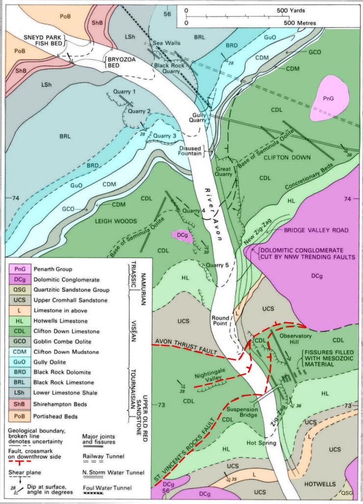
As I live not very far from the Avon Gorge, many of my walks have been along the gorge. If you have driven along the Portway, you will know that it is a busy, noisy thoroughfare, often hard up against the cliffs of the gorge. It is not a place for quiet geologising.
But, walking along the gorge, I soon realised that my knowledge of the geology was very superficial. So for my own satisfaction I started looking more deeply into the details.
There are no great insights in this article – its main purpose is for me to clarify my own thoughts on this spectacular feature. I follow the mapping of the Geological Survey and try to put the geology onto my photos. If I get it wrong please let me know. The Geological Survey Memoir can be seen HERE. I purchased an old copy of the memoir from an online book dealer.
There is one exception to this. Richard Arthur, a fellow geologist, has been doing some “On The Rocks“ geology and has some new discoveries and reinterpretations. Those for the Great Quarry have been incorporated into the article. There may be more to come!
Even during the most intense periods of the lockdown there were always vehicles speeding along the road. Getting close to some of the outcrops would have been life-threatening!

So most of my photos were taken from the pavement on the river side of the Portway, or from across the river. You can get near the cliffs in the Black Rock, Gulley and Great Quarries and various paths down to the Portway. But often there is a great deal of undergrowth. Photos in the Memoir show outcrops which can no longer be seen.
The first photograph on this page is of Shirehampton Beds. I could not find any of the Lower Limestone Shales – I suspect you would need to trespass onto the railway line as it come out of the tunnel under the Downs to see good exposures. This is not recommended!

Below the Shirehampton Beds is the Portishead Formation of the Old Red Sandstone. I have one photograph of it from across the Avon. You can see it below.

All the photographs on this page are georeferenced. (Except for the annotated ones.) Click on the photo and you are taken to a larger version of the photo. Click on the “i” icon on the left and a map showing where the photo was taken appears. This is usually quite accurate but sometimes the presence of nearby cliffs bouncing elecro-magnetic waves, causes some errors.
The rest of this page is concerned with the Avon Gorge and hence the Carboniferous Limestone. We will start with the oldest in Black Rock Quarry and move southwards to examine the younger parts of the Carb. Lime.


And here is a more detailed version.#Succession

Black Rock and Gully Quarries
The next rocks in the succession are spectacularly exposed in Black Rock Quarry. The geology of the quarry and the contiguous Gully Quarry is fairly straight forward and is summarised in the photos below. Both photos are based on a panorama taken from the footpath on the other side of the Avon. The lower one has had the geology added.
I have taken many other photos of the quarries and they can be seen HERE. Some selected ones are on another page of this web site. You can get to it HERE.


The Geological Surveys Memoir is sparing in its description of the Black Rock Limestone – in contrast to the overlying rocks. The following is the most relevant part of the description:-
The Black Rock Limestone is the lowest of three groups recognised within the main ‘Mountain Limestone’ facies of the Lower Carboniferous. It consists almost entirely of calcareous or dolomitic rocks and unlike the succession above, it contains only thin argillaceous beds and no arenaceous deposits. The name derives from the old quarrymen’s name for the dark limestones so extensively quarried on the sides of the Avon Gorge between Clifton and Sneyd Park.
For the most part the sequence comprises dark grey to black, fine-grained, coarsely crinoidal limestone, which in places approaches a ‘petit granit’ in character. By careful examination of the abundant faunas, it has been shown that the upper part of the thick Mendip sequence is missing from the Avon Gorge succession (Mitchell, 1981). This northwards attenuation has been accompanied by by strong dolomitisation extending increasingly downwards from the surface of unconformity below the Clifton Down Group.
A great deal of the information about the Black Rock Group and the sediments below it comes from a foul water tunnel which I did not know to exist. It runs from the bottom of the gulley to Sea Mills. I hope it ends up at the Avonmouth sewerage works. It was logged by the Survey and gives the complete succession.

What I find most interesting in the Black Rock Quarry is the dolomite. Despite being one of the most common rocks on the surface of the earth, it is currently being produced in very few and limited environments.
BGS, in the memoir, tell us the following:-
Dolomitised, crinoidal or oolitic limestones which have been altered during late stage diagenesis or after consolidation has taken place have probably been affected by more than one phase of alteration, producing excessively hard, purplish grey rocks in which the MgO content rises to about 15 per cent. Weakly dolomitised limestones contain about 5 per cent MgO, below this figure the rock can only be described as a magnesian limestone, and is not usually mapped as a dolomite. In the Avon Gorge, for example, the highly dolomitised, purplish grey ‘laminosa dolomite’ in the Tournaisian Black Rock Group is overlain by the white, current- bedded Viséan Gully Oolite (Figure 8). The contact has been affected by dolomitisation and is not clearly defined. Palaeontological evidence shows that there is a major non-sequence at the base of the Viséan, and part of the dolomitisation may date from that period when a drop in sea level or a rise in the level of the landmass increased the hydrostatic pressure in the migrating groundwater. There is postdiagenetic dolomitisation, since in places both the Black Rock Limestone, below the break, and the Gully Oolite, above the break, are dolomitised. The diagenetic (or later) processes at the Tournaisian-Viséan boundary in the Avon Gorge are generally characteristic of the Bristol Shelf as a whole, although dolomitisation becomes more severe north- westwards.
Dolomitisation of the main mass of the Black Rock Limestone was largely by refluxion, that is by the deep circulation of Mg-rich brines (Figure 7), and may have been well advanced before Viséan subsidence took place. Correlatives of the Black Rock Group and the Gully Oolite are much more strongly dolomitised on the Chepstow Shelf and in the Forest of Dean, particularly in the Wigpool Syncline (Trotter, 1942, Welch and Trotter, 1961).
On a more generalised approach to dolomitisation they say:
Dolomitisation is an important feature of the Dinantian succession around Bristol. Excluding secondary Triassic dolomitisation, two main types of dolomite can be distinguished in the local Carboniferous Limestone. Fine- grained dolomite-mudstone, commonly associated with beds of calcilutite and argillaceous mudstone, is typically developed in the Clifton Down Mudstone. For example, the algal and stromatolitic limestones of the Clifton Down Group are accompanied by dense, fine-grained, unfossiliferous dolomites. These resemble the dolomite muds being deposited at the present day in coastal lakes and lagoons under semiarid climatic conditions in the Coorong of South Australia (Von der Borch et al., 1975, Von der Borch and Lock, 1979).
The second type of dolomitisation is characterised by changes produced in thick limestone sequences which have been penetrated by groundwaters moving seawards under pressure generated in supertidal areas. In the cases of the Chepstow, Bristol and Wickwar shelves the areas of active uplift marked by the Usk Anticline and other structures to the north and east may have provided the groundwater with sufficient hydrostatic pressure for deep seaward movement, causing it to combine with connate water to form strong refluxing brines. The converse situation is seen in the case of the Goblin Combe Oolite on the Bristol Shelf where a short- lived marine transgression had led to an influx of oceanic water which has temporarily suppressed dolomitisation.
There is a third type of dolomitisation (of Triassic age) which affects all the Dinantian rocks locally. It can usually be identified by its geological context and by the presence of red zoning in the dolomite crystals.
Early studies of dolomitisation and lagoon-phase deposits carried out by Dixon (1907) were published in the Geological Survey’s Memoir on the Geology of the South Wales Coalfield, Part VIII, the country around Swansea (pp.13-20) and in a paper on Gower by Dixon and Vaughan (1911). This work was subsequently extended to Bristol by S. H. Reynolds (1921). Investigations at the Coorong mentioned above provide results which are in line with many of Dixon’s conclusions. The Clifton Down Mudstone (Canine-dolomite of Vaughan, 1905, 1906) is the most convincing example of a lagoonal deposit, with primary dolomite and magnesia limestones locally interbedded with mud of terrigenous and volcanic origin. The strong discontinuity at the base of the Clifton Down Mudstone in the Avon Gorge (p.33) is more clearly marked at Wick in the east and Kingsweston in the west. Farther north, in the Chepstow- Forest of Dean area it is even more pronounced. Yet the formation of the shelf on which the Gully Oolite and Clifton Down Mudstone were laid down had largely been accomplished before the Sub-Oolite Bed (p.31) filled the hollows on its surface.
The dimensions of this great lagoonal complex, which it is proposed to call the Dixon Lagoon are most surprising. Its western extremity lay at or beyond Milford Haven while in the east it continued to Bath or beyond. Its total length was in excess of 120 miles and its width, some 10-15 miles in Glamorgan, was more than 30 miles in extent between the Forest of Dean and Broadfield Down south of Bristol.
The closing stages in the life of the eastern part of the great lagoonal belt were presaged by a marine incursion from the south leading to the deposition of the Goblin Combe Oolite (p.41). The final breakdown was marked by sand with drift- wood carried from the northern uplands down the channel marking the Malvern Fault Zone, and the deposition of the Lower Cromhall Sandstone (p.37)
All very interesting but I still do not understand dolomitisation! THIS ARTICLE may be the easiest for me to get to grips with dolomitisation.
As you go eastwards (upstream) the cliffs become steep slopes. In their survey of the gorge, BGS were able to find outcrops of Goblin Combe Oolite. The photo below shows what it is like now – I couldn’t even get into the area! – and would I recognise Goblin Combe Oolite if I saw it!
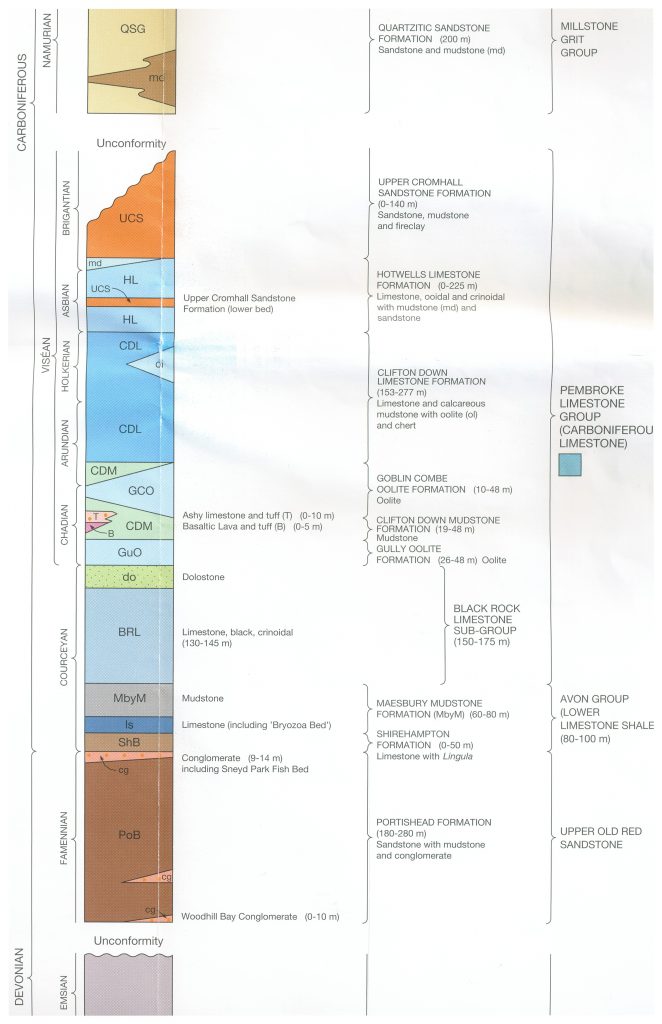
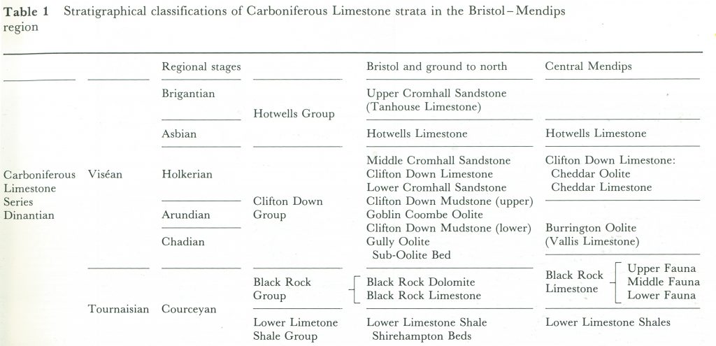
We have moved up in the Carboniferous statigraphy. The Black Rock Limestone and Dolomite are in the Tournaisian. The rest of the succession is in the Visean. BGS’s classification is given below.

The photo below shows the BGS interpretation of the geology.

When we get to the Great Quarry we find some rocks to look at. They are Clifton Down Limestone. At the southern end of the quarry there is a sliver of Hotwells limestone.
The most important details of the Geology of The Great Quarry are shown below. More photos can be seen HERE. These allow a more detailed look at the quarries geology.


This view of the quarry was taken from top of the gorge on the other side of the river.
In contrast with its description of the Black Rock Group, the memoir goes into great detail about the stratigraphy of the Clifton Down Limestone. I quote it below:-
The Clifton Down Mudstone is overlain by the Clifton Down Limestone, a variable sequence of rocks, well exposed in the Great Quarry, on the right bank of the Avon Gorge and on the roadside extending northwards along the Portway. The sequence begins with a limestone bearing sand grains, marking the onset of the Cromhall Sandstone sedimentation (Kellaway and Welch, 1955, p.17), which became so widespread later in the ground to the north and north-west (see below). This limestone is succeeded by relatively unfossiliferous, uniform, splintery calcite- and dolomite-mudstones, some of them stromatolitic, generally similar to the underlying Clifton Down Mudstone, but more regularly bedded, they represent a continuation of shallow- water lagoonal conditions gradually giving way to more open-water conditions. These beds pass upwards through fossiliferous limestones with shale partings into massive medium to dark grey limestones with colonies of Lithostrotion martini and bands of Composite ficoidea and Linoprotonia. Several locally identifiable bands are noteworthy in this part of the sequence. At the northern end of the Great Quarry a bed containing a diphyphylloid Lithostrotion was termed the ‘Diphyphyllum Band’. Some distance above, four other local markers occur in close succession – the Lithostrotion basaltiforme Bed, the Trilobite Bed, the Fluorite Bed and the Caninia bristolensis (Caninophyllum archiaci` var. bristolensis) Bed (Reynolds, 1921, p.241) (see Figure 13). These beds, however, have little persistence and they are of only limited use for correlation. There is some evidence that the Fluorite Bed, situated some 26 in above the Trilobite Bed in the Avon Gorge (Loupekine, 1951, 1953), may extend westwards as far as Lawrence Weston.
Not far above there is another sharp change in lithology, and oolites and oolitic limestones again become prominent. In the Avon Gorge two such developments are well marked and have been named the Seminula Pisolite and the Seminula Oolite (Reynolds, 1921, pp.228-229). Silicified fossils occur in the Seminula Pisolite, including Composita and Lithostrotion and near the top of the bed there are three bands of chert, which are separated from the Seminula Qolite by about 5 ft of cavernous dolomite. The Seminula Oolite, in particular, has a very sharply defined base, and Reynolds also noted a ‘considerable lateral variability’ in the underlying beds. It seems probable, therefore, that there is a srtatigraphical hiatus at this level, developed on the Bristol shelf. Traced laterally, it is seen that these oolites are part of a series of such developments, which may collectively be called the Clifton Down Oolite. The individual beds can seldom be mapped over any great distance, as they tend to pass laterally and vertically into non-oolitic limestone. In the Avon Gorge the Seminula Oolite grades upwards through oolitic limestones into limestones with Lithostrotion and then a thick sequence of calcite-mudstones, which mark a return yet again to the shallow lagoon conditions characteristic of the group as a whole. Finally these calcite-mudstones become markedly algal and stromatolitic in character and are interbedded with thin shales and brecciated limestones. These Concretionary Beds (Figures 8 and 13) have their maximum development in the area around Bristol, but they extend southwards to the northern and western sides of Broadfield Down and to Long Ashton, Belmont Hill and Cambridge Batch. They cannot be identified on the eastern side of the Coal Pit Heath Basin and they may be replaced by the Middle Cromhall Sandstone which persists as far south as Wick.
Continuing upstream the next rock group is the Hotwells Limestone. It first makes its appearance, high up at the southern end of the Great Quarry.

The above photograph illustrates the steepness of the terrain and the density of the vegetation. The photo below puts names to the rocks.

The authors of the memoir write a lot about the Hotwells Limestone, but not a lot about it in the Avon Gorge. This is probably due to the incompleteness of exposure.
The upper part of the Clifton Down Limestone and much of the Hotwells Group are seen in the roadside section adjacent to the Portway. The exposures are not continuous however and even at the time of the construction of the Portway when the new cuttings were measured by S. H. Reynolds and F. W. Wallis (Reynolds, 1926) it was impossible to construct a complete section through the Hotwells Group north of the Avon Thrust. In the Avon Gorge section shown in Figure 13 all the evidence presented by Reynolds has been incorporated, although less than half the thickness of the Hotwells Group can be measured in detail. Apart from poor exposure, there are structural complications which no doubt affect the sequence. The Point Villa section, as it was formerly known (Reynolds, 1926, 1936), is well shown in two photographs published by Vaughan (1906, pls 8,9). Point Villa was demolished during the construction of the Portway, but the least disturbed part of the section, including the richly fossiliferous limestones with Lonsdaleia and Palaeosmilia regia are well seen in Vaughan’s plate 9. This group of limestones, which correlates with the coral-rich horizon at Rhododendron Walk in Blaise Castle Woods (Figure 17), the Rownham Hill Coral Bed and the Castle Wood Limestone of Wick, was also proved in the Ashton Park Borehole (Kellaway, 1967). It is by far the most important of the marker bands in the Upper Cromhall Sandstone and can be traced to Henbury and Over in the north and north-west, to Wick in the east, and at least as far south as Wrington in Somerset.
Near the foot of Bridge Valley Road and immediately to the north of the Avon Thrust Fault the strata forming the footwall of the fault are too highly sheared and folded for accurate measurements. The thicknesses shown in Figure 13 are those measured by Wallis (in Reynolds, 1926, p.322) but the original descriptions make it clear that the rocks are highly disturbed.
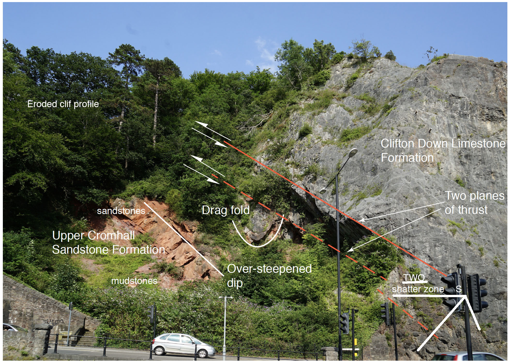
The Avon Thrust
The most important details of the Avon Thrust are shown below. More photos can be seen HERE. These allow a more detailed look at the geology of the thrust.
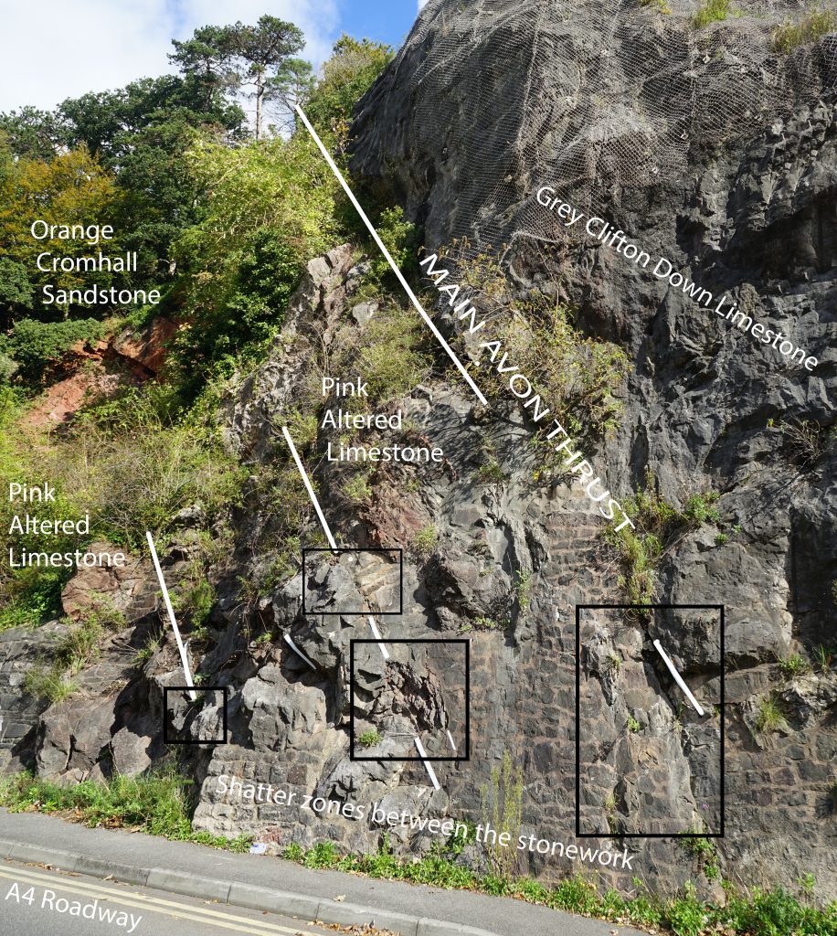

Between the thrust fault and the St Vincent’s Rocks Fault the Clifton Down Limestones are affected by the thrusting. There is a reddish bed which I first thought must be Cromhall Sandstone but the mapping shows it to be Clifton Down Limestone. It is not far below the Dolomitic Conglomerate, so perhaps the bed has been haematised along its joints. It is rather difficult to approach but if you follow the bed by eye, down dip, and further from the Triassic, you will see that the red colouration disappears
The Suspension Bridge Area
The most important details of the gorge around the Suspension Bridge are shown below. More photos can be seen HERE. These allow a more detailed look at the geology of the thrust.
The St Vincent’s Rocks Fault is a thrust fault but here it brings Clifton Down Limestone over Clifton Down Limestone. Outwith the rocks between the thrust faults, thrusting is minor.


Upstream from the Suspension Bridge the succession continues. At road level the Hotwells Limestone appears at the Zig Zag path. The Clifton Rocks Railway is in the Hotwells Limestone.


At the southern entrance to the Avon Gorge we have Windsor Terrace perched on a ridge of Upper Cromhall Sandstone.

The Origin of the Gorge
I was told, while a student, that the gorge was superimposed drainage. An ice sheet closed Ashton Vale and the Gordano valley – the easy way to the sea – forcing the Avon to cut a new course through the Avon Gorge.
The memoir says very little about the origin of the gorge and does not commit to any explanation. More recent publications give their opinions. Sometimes they have more than one!
The book produced in 2018 by the Bristol Regional Environmental Records Centre, “Geological Sites of the Bristol Region”, (ISBN 978-0-9545235-3-4) and available from Bristol City Museum, is one of these!
On page 91, the origin of the gorge is given in a single paragraph.
The Formation of the Gorge
it’s difficult to imagine Bristol without the gorge, but until only a few thousand years ago, the Avon Gorge was simply not there. The River Avon winds an unusual course through the landscape around Bristol which has led to speculation on how the gorge came into being. One theory suggests that at the end of the Last Glacial Maximum, when Bristol was on the eastern edge of a large ice sheet and sea levels were low, huge areas of ice blocked the river’s natural course through Ashton Vale forcing the river to change course.
So the river cut down through the Dolomitic Conglomerate and then the Carboniferous to get to sealevel, forming the gorge. This was what I was taught as a student.
On pages 28 to 31 a more modern version is presented. I do not want to summarise it, so show it in full below.
Drainage Patterns in the Bristol Region
The rivers in the area generally follow a simple pattern. Those on the Cotswold scarp slope flow down slope into the River Severn; and those on the Cotswold dip slope flow eastwards down dip towards the River Thames catchment. Likewise streams on the Mendip Hills anticline flow down the structure and those in the valleys flow westwards towards the Bristol Channel. The exception to this pattern is the River Avon.
The Evolution of the River Avon
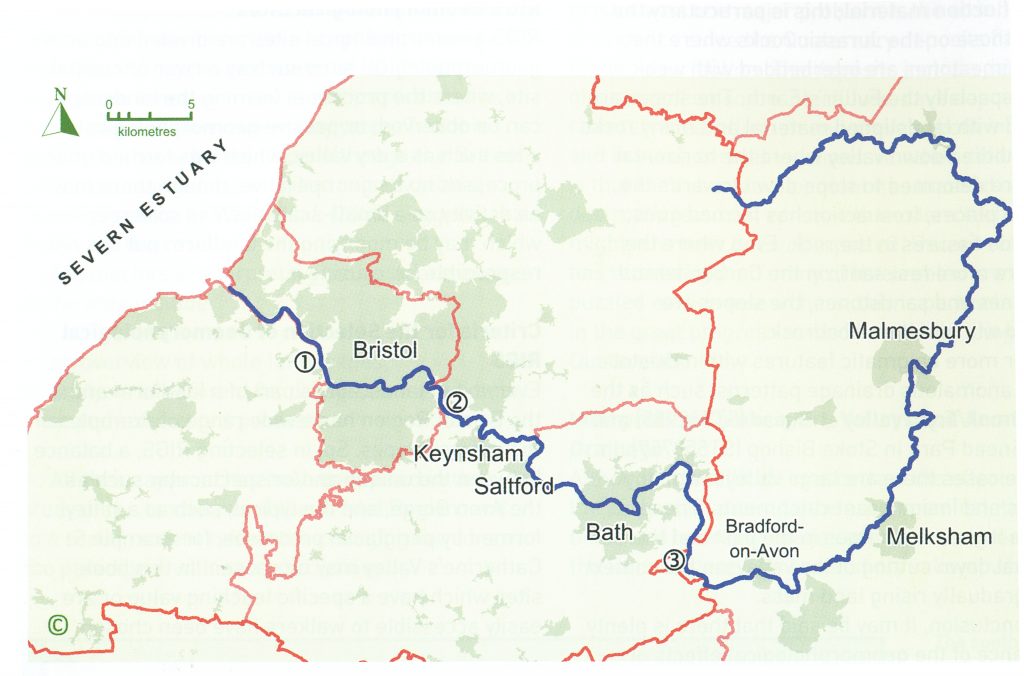
The Bristol Avon rises near the village of Acton Turville in South Gloucestershire before taking an almost circular course to reach the Severn Estuary at Avonmouth. The river is approximately 120km in length, although as the crow flies, the distance from source to mouth is only about 30km. The river initially flows eastwards down the Cotswolds dip slope, but then takes a southwesterly course across the strike of the rocks and flows north through Limpley Stoke Gorge to Bath, and then in a northwesterly direction through two gorges, one at Hanham and finally through the Carboniferous Limestone forming the gorge at Clifton. However, the river has not always taken its current route.
There has been a long history of research on the origin of the River Avon, but there is general agreement that the river initially developed on a cover of younger rocks, which have since been removed (Green, 1992). An earlier interpretation suggested that the gravel deposits and drainage anomalies were caused by early glaciations. However, in recent years a much greater understanding has been reached about the factors which control long-term landscape evolution, including that of the River Avon.
These factors include:
Milankovitch cycles which drive climate change and the ensuing extreme climatic conditions of severe cold periods glaciations, periglacial processes and increased fluvial activity. followed by more temperate periods;
tectonic movements during the Tertiary and during the Quaternary; and
the part which rivers play in redistributing eroded material.
Mid-Wales towards the South Coast
The first proto-Bristol Avon is believed to have flowed from the uplands of mid-Wales towards the south coast of England. Recent work based on the evidence of off-shore deposits enabled Gibbard and Lewin (2003) to reconstruct former drainage pattern which evolved on low-relief landscapes alongside fold development during the Palaeogene. Erosion and uplift kept abreast, maintaining a landscape of low-relief which persisted into the Pleistocene. In the late Pliocene and early Pleistocene, drainage of the proto-Avon had its headwaters in mid-Wales, and the river probably flowed towards the present English south coast
Mid-Wales to East Anglia
The courses of the early rivers had been stable throughout the greater part of the Cenozoic – a period of over 63 million years. But climate and sea-level changes during the Pleistocene caused rapid erosion and incision. The effects of the Pleistocene glaciations, the periglacial activity and the frequent changes of sea-level during this period affected the rivers more dramatically than in the preceding long timespan.
Due to the landscape changes in the Pleistocene, the course of the proto-Avon was altered, so that it then flowed from mid-Wales to East Anglia. Evidence that the River Avon flowed from west to east comes from early Pleistocene deposits in East Anglia: the Kesgrave sands and gravels (Rose et al., 2001). The petrology reveals volcanic rocks and Carboniferous chert which were derived from Wales and the Bristol Region in these East Anglian deposits, from a time when the River Avon contributed to the Thames catchment (before the Anglian glaciations of MIS 12). In addition, by looking at the amplitude and pattern of the meanders, Frey (1975) suggested that the river flowed eastwards as a continuation of the River Wye, prior to the evolution of the River Severn.
Changes due to Regional Uplift
Research during the 21st century has deepened the understanding of regional uplift and complementary subsidence in adjacent regions, and the significance of this in the development of river and landscape patterns, especially when considered within the context of climate change. Although this has not been applied directly to the Bristol Avon, the general model, by inference, must apply as it relates to all the surrounding regions.
During the Pleistocene, the land surface in the region was subject to uplift. Westaway (2002) suggested that during the inter-glacials, the increased weight of sea water and glacial melt-water on the surface pushed down on the Earth’s crust. Consequently in areas with a weak crust, such as the Rhine-Thames basin off eastern England, the increased weight on the surface caused subsurface crustal flows to develop deep within the lower crust. This then produced flexing and compensatory uplift in adjacent regions, for example across the Midlands and south central England (Westaway, 2010).
Further, Watts et al., (2005), showed that surface unloading, as a consequence of river excavation, can bring about uplift due to flexuring of the Earth’s crust. Features along many rivers, including the River Thames and River Thame, support this idea: heights of the river terraces became lower as the land rose due to uplift.
This flexuring raised the flanks of the surrounding regions and changed the drainage patterns, such that rivers which once flowed to the east changed part of their course to flow west. The sediments in East Anglia reflect this sudden change in drainage pattern, since pebbles derived from the west no longer appear in East Anglian deposits. The date of the change from an eastward-flowing river cannot be precise; all that can be said is that it must have occurred at some time prior to the Anglian glaciation (MIS 12).
The Cotswold scarp must also have originated from this time, with the rivers draining it flowing westwards towards the Severn basin being relatively young. Since that time, these rivers have cut back into the escarpment at different rates, related to the hardness of the rock.
There is no evidence that the River Severn existed before the Anglian glaciation (Bridgeland, 2010). The development of the River Severn as a consequence of the Anglian glaciations, meant that the Bristol Avon ceased to be linked to the headwaters in South Wales. It appears that sometime after this glaciation, the direction of flow of the Bristol Avon changed from flowing eastwards to its present direction towards the River Severn estuary-Bristol Channel. To date no detailed research has been undertaken in the critical area between the source of the River Avon and Chippenham.
In this context the Avon Gorge can be explained quite simply. As the river’s course developed on younger rocks, now eroded away, the pattern continued down through the hard rocks of the Carboniferous limestone as the uplift continued. This conforms to one of the older theories, that of superimposed drainage which attempted to explain why the river cut through the gorge, rather than following the seemingly easier route through the Gordano valley. Previously it was difficult to explain the cause of the uplift as it was thought the area was tectonically stable.
It can be concluded that regional uplift coupled with glacial activity peripheral to the River Avon caused the perturbations to the direct eastward-flowing river. In addition, the greater understanding of crustal flexuring and the associated uplift affords an explanation of the incised rivers of the Bristol Region.
Clues to the Present Course
River terraces frequently give clues to the history of a river valley. There are several terraces between Bristol and Bath which are described by Hunt (1998]. The 30m terrace at Ham Green is regarded as being important since it relates to the ancient glacial deposits found in the Bristol area. The Geological Conservation Review (Hunt, 1998) records the site at Newton St Loe, within a terrace 10m above the present river, which is composed of gravel and sand associated with cold stage sedimentation. Pebbles here show a complex provenance, with material from South Wales and Midlands sources. They are weathered and decalcified as a consequence of interstadial weathering, as well as cryoturbation reflecting a cold stage.
Dating of the river terraces of the Avon may throw light on the age of the present course. Bates and Wenban-Smith (2005) report that artefacts appear to date from the Middle Palaeolithic and that further research would be useful. It appears that there is insufficient evidence to relate these two significant terraces in terms of age. The existence of Welsh-sourced pebbles at Newton St Loe suggests that the change in direction of the flow occurred during or immediately after the Anglian glaciation, as it was after the Anglian glaciation that the Severn developed and cut off the source of this supply of sediments.
There does seem to be some evidence for this theory and it does give about half a million years for the gorge to be eroded, in contrast to the few thousand years of the glacial theory. So I will stick with this until something better comes along!